


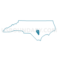
Voting District PLVW, Sampson County, North Carolina
About
Outline

Summary
| Unique Area Identifier | 641383 |
| Name | Voting District PLVW |
| County | Sampson County |
| State | North Carolina |
| Area (square miles) | 38.43 |
| Land Area (square miles) | 38.37 |
| Water Area (square miles) | 0.05 |
| % of Land Area | 99.86 |
| % of Water Area | 0.14 |
| Latitude of the Internal Point | 35.25227400 |
| Longtitude of the Internal Point | -78.52803650 |
Maps


Graphs
Select a template below for downloading or customizing gragh for Voting District PLVW, Sampson County, North Carolina


Neighbors
Neighoring Voting District (by Name) Neighboring Voting District on the Map
- Voting District MING, Sampson County, NC
- Voting District PR02, Johnston County, NC
- Voting District PR18, Johnston County, NC
- Voting District PR25, Harnett County, NC
- Voting District WBRK, Sampson County, NC
Top 10 Neighboring County Subdivision (by Population) Neighboring County Subdivision on the Map
- Averasboro township, Harnett County, NC (13,018)
- Banner township, Johnston County, NC (6,833)
- Plain View township, Sampson County, NC (5,095)
- Meadow township, Johnston County, NC (3,366)
- Westbrook township, Sampson County, NC (1,812)
Top 10 Neighboring Place (by Population) Neighboring Place on the Map
Top 10 Neighboring Unified School District (by Population) Neighboring Unified School District on the Map
- Johnston County Schools, NC (168,878)
- Harnett County Schools, NC (114,678)
- Sampson County Schools, NC (47,622)
Top 10 Neighboring State Legislative District Lower Chamber (by Population) Neighboring State Legislative District Lower Chamber on the Map
Top 10 Neighboring State Legislative District Upper Chamber (by Population) Neighboring State Legislative District Upper Chamber on the Map
- State Senate District 12, NC (210,500)
- State Senate District 22, NC (202,925)
- State Senate District 10, NC (181,431)
Top 10 Neighboring 111th Congressional District (by Population) Neighboring 111th Congressional District on the Map
Top 10 Neighboring Census Tract (by Population) Neighboring Census Tract on the Map
- Census Tract 414, Johnston County, NC (6,695)
- Census Tract 9702, Sampson County, NC (6,635)
- Census Tract 9703.01, Sampson County, NC (6,549)
- Census Tract 413, Johnston County, NC (5,991)
- Census Tract 9703.02, Sampson County, NC (5,132)
- Census Tract 701, Harnett County, NC (4,530)
- Census Tract 702, Harnett County, NC (3,262)